Doppler 10 Weather Resources: Interactive Radar | Live Radar | Weather Warnings | Updated Forecast
10TV Meteorologist Jeff Booth is tracking showers and storms with our potential severe weather later today moving through central Ohio Sunday:
9:00 p.m. Update: Areal Flood Warning for Ashland County until 3:00 a.m. Monday.
___
7:54 p.m. Update: Severe Thunderstorm Warning for Jackson County until 8:30 p.m.
___
7:30 p.m. Update: Severe Thunderstorm Warning for Scioto County until 8:15 p.m.
___
6:40 p.m. Update: Flood Warning for Marion County.
___
3:05 p.m. Update: Severe Thunderstorm Watch for Pike, Ross and Scioto County until 11:00 p.m.
___
1:00 p.m. Update: Flood Warning for Hancock County
___
12:00 p.m. Update: Flood Warning for Ashland and Richland County until 9:00 p. m. Also Grindell Rd, Miller Rd and Beth-Claibourne Rd due to high water, according to the Union County Sheriff's Office
___
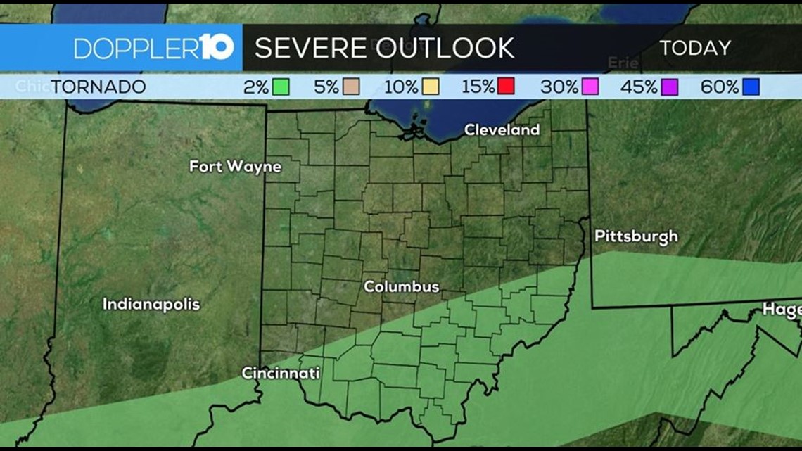
10:45 a.m. Update: Severe weather risk for today has been upgraded to a slight risk for areas along and south of I-70. This is the area that could see the greatest potential for strong to severe storms. Primary threats are strong, damaging winds and locally heavy rainfall. While the risk is small, a tornado or two cannot be ruled out for those in southern and southeastern Ohio.
Timeframe for these storms will be this afternoon and evening. Storms will begin to reignite during the break we have from this mornings rain. Any sunshine we see today will create a more conducive environment for stronger storms later today. Strong factors contributing to today’s severe weather potential will be how much the clouds break and how much we warm up and also where exactly this frontal boundary sets up. As of now, areas along and south of I-70 are where the most ripe ingredients will be for storm development later today.

10:30 a.m. Update: Areal Flood Warning for Morrow County until 7:45 pm Sunday.
9:00 a.m. Update: Tornado sirens sound in Fairfield County; no severe weather threat
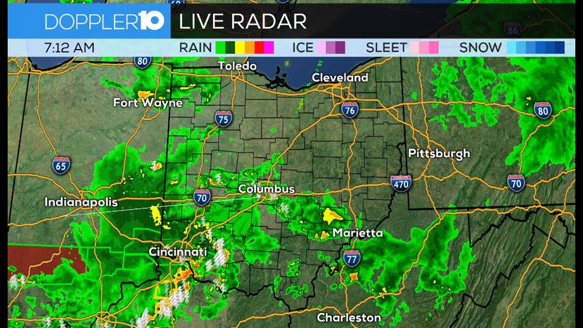
8:30 a.m. Update: Widespread heavy rain will move through central Ohio this morning. Flash flooding is the primary concern. Severe Thunderstorm Warning for Scioto County until 8:45 am.
Many locations could see an additional 1” or so of rain by tomorrow morning.
7:45 a.m. Update: Heavy rain moving through Columbus this Father’s Day morning. Many areas have been dealing with flooding due to the amount of rain that has fallen over the past 24 hours.
6:45 a.m. Update: Heavy rain this morning with scattered showers and storms for Sunday. FLASH FLOOD WATCH: for Central/Northern Ohio to Sunday evening

_____
SEVERE WEATHER SAFETY GUIDE
DIFFERENCES BETWEEN WATCHES & WARNINGS
Watch
A Watch indicates the possibility of severe weather in a relatively broad area. For instance, a tornado watch means conditions are favorable for the development of tornadoes. Go about your normal routines, but watch for threatening weather.
Warning
A Warning is issued when severe weather is actually occurring. For instance, a tornado warning means a tornado has actually been sighted or has been indicated by radar. The warning usually encompasses a relatively small geographic area. If a warning is issued for the area in which you live, take cover immediately!
---
TORNADOES AREN'T THE ONLY REASON TO STAY ALERT
Strong Winds
Strong winds of 55 mph or more can cause significant damage even though no tornado is present. "Downbursts" are columns of air that slam to the earth and spread high winds in many directions. Downbursts can be just as damaging as tornadoes; if such conditions are present, take the same precautions as you would for a tornado.
Lightning
Lightning claims more lives every year than tornadoes. When lightning is a threat, stay indoors and don't use electrical appliances. If you're caught outside, keep a safe distance from tall objects, and try to stay lower than anything nearby. A safe distance from a tree is twice its height.
---
TAKING COVER
Storms producing tornadoes in Ohio often approach from the southwest. They can travel at speeds up to 70 miles per hour and contain winds estimated at over 200 miles per hour.
Sometimes an approaching tornado will sound like the roar of a train or airplane. If you see or hear a tornado, take cover immediately. Seek shelter inside, preferably below ground level. Do not waste time opening windows; tornado-force winds will "open" the windows well before the pressure difference can cause any structural damage. Above all, protect your head and lie flat.
At Home
Get away from windows, doors and outside walls. Go to the basement. If you have no basement, go to a first floor bathroom, closet or room at the center of the house. If possible, get under heavy furniture and cover your head with blankets or pillows.
At School
Go the lowest floor or basement. Go to small interior rooms or hallways. Stay away from windows and avoid auditoriums, gyms and other areas with wide, free-span roofs.
In Public Buildings
Go immediately to the designated shelter area or to an interior hallway or small room on the lowest level. Stay away from windows. Do not use elevators. Do not go to your car.