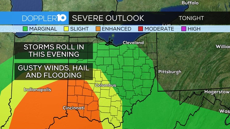
The NOAA NWS Storm Prediction Center has us under a risk for strong to severe storms today. Threats include damaging wind gusts, hail and isolated tornadoes.
I just went through the latest data and it looks like the best chance for strong tornadoes will be well south of the area but in SW Ohio (and possibly into the southern part of our viewing area) the potential for isolated tornadic activity exists.
Doppler 10 weather Resources: Interactive Radar | Live Radar | Weather Warnings | Updated Forecast
It looks like by the time this moves into the area we'll see our storms developing into more of a squall line which would be more conducive to strong damaging straight-line winds.
These squall lines can have embedded spin-up tornadoes with them but they tend to be on the weaker side and develop/dissipate rather rapidly. We'll still need to watch out for anything that develops out ahead of the line as we'll get warm enough to develop moderate instability at the surface. Again, we'll also have to watch out for hail with these storms as well.
Right now the timing of the strongest weather will be from about 7-11 p.m. in central Ohio but the overall timeframe for the entire area will be about 6 p.m. - midnight. This means that as these start to really get going around and after 7 p.m. we'll have already hit peak daytime heating and the atmosphere won't be quite as unstable.
This is why I think there's a better chance for the strongest storms to develop south and SW of us. I'm going to be watching this throughout the day and I'll update as needed.
SEVERE WEATHER SAFETY GUIDE
DIFFERENCES BETWEEN WATCHES & WARNINGS
Watch
A Watch indicates the possibility of severe weather in a relatively broad area. For instance, a tornado watch means conditions are favorable for the development of tornadoes. Go about your normal routines, but watch for threatening weather.
Warning
A Warning is issued when severe weather is actually occurring. For instance, a tornado warning means a tornado has actually been sighted or has been indicated by radar. The warning usually encompasses a relatively small geographic area. If a warning is issued for the area in which you live, take cover immediately!
---
TORNADOES AREN'T THE ONLY REASON TO STAY ALERT
Strong Winds
Strong winds of 55 mph or more can cause significant damage even though no tornado is present. "Downbursts" are columns of air that slam to the earth and spread high winds in many directions. Downbursts can be just as damaging as tornadoes; if such conditions are present, take the same precautions as you would for a tornado.
Lightning
Lightning claims more lives every year than tornadoes. When lightning is a threat, stay indoors and don't use electrical appliances. If you're caught outside, keep a safe distance from tall objects, and try to stay lower than anything nearby. A safe distance from a tree is twice its height.
---
TAKING COVER
Storms producing tornadoes in Ohio often approach from the southwest. They can travel at speeds up to 70 miles per hour and contain winds estimated at over 200 miles per hour.
Sometimes an approaching tornado will sound like the roar of a train or airplane. If you see or hear a tornado, take cover immediately. Seek shelter inside, preferably below ground level. Do not waste time opening windows; tornado-force winds will "open" the windows well before the pressure difference can cause any structural damage. Above all, protect your head and lie flat.
At Home
Get away from windows, doors and outside walls. Go to the basement. If you have no basement, go to a first floor bathroom, closet or room at the center of the house. If possible, get under heavy furniture and cover your head with blankets or pillows.
At School
Go the lowest floor or basement. Go to small interior rooms or hallways. Stay away from windows and avoid auditoriums, gyms and other areas with wide, free-span roofs.
In Public Buildings
Go immediately to the designated shelter area or to an interior hallway or small room on the lowest level. Stay away from windows. Do not use elevators. Do not go to your car.