COLUMBUS, Ohio — Snow has moved out of central Ohio, but the frigid cold temperatures will stick around a bit longer.
Most of central Ohio saw about a half inch of snow with more accumulation as the winter weather moved into the southeastern part of the state. Lancaster saw about 1.5 inches while Athens saw just over 2 inches.
The rest of the night will be frigid with wind chills in the single digits. Highs on Friday will be in the 20s.
There will be some slick spots on the roads on Friday, but with the sun, most of the snow should melt away.
Average temperatures for this time of the year will return on Saturday with a chance of rain on Sunday.
Weather Resources: Interactive Radar | Watches & Warnings
___
Original Forecast
A weak cold front will move through this evening, bringing in much colder air for Thursday. This will set the stage for not only a frigid start to the day but also the potential for snow to fall Thursday afternoon.
Wind chills will be in the single digits and contesting subzero values to start Thursday with an otherwise frigid day ahead. Afternoon highs will be in the mid-20s under mostly cloudy skies.
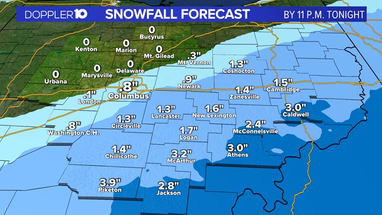
Some of our higher resolution models have now been able to pick up on Thursday's event, which is still showing most of the accumulating snow south and east of Columbus.
Amounts still support under an inch of snow for Columbus and locations along I-71. A couple of inches of snow will be possible for locations east of I-71 and along/south of I-70. The higher amounts will be in southeastern Ohio, especially for locations closer to the Ohio River.
Snow will start off scattered Thursday afternoon and will pick up from time to time during the evening commute. Snow will then gradually taper off into the early part of the night.
Snowfall amounts will also increase from the northwest to the southeast. Locations west of I-71 will likely see a dusting to a coating of snow. Areas east of I-71 will see up to an inch in spots, with a couple of inches possible for counties further south and east.
While we are within 24 hours of this event taking place, there can still be some adjustments in the forecast as more and more weather data becomes available. Also, while this is not expected to be a significant weather event here in central Ohio, much of this snow will be falling during the evening commute, so please allow for some extra time when traveling.
Models are still hinting at up to an inch of snow across Columbus and areas west of I-71.
Nearby counties just south and east of Columbus will be in the 1-2” range.
Counties south and east of Ross County will be in the 1-3” range, with the higher amounts being closer to the Ohio River.
Stay tuned for more updates from the Doppler 10 Weather Team.
Weather Resources: Interactive Radar | Watches & Warnings


