
COLUMBUS, Ohio — The National Weather Service issued several severe thunderstorm warnings as storms moved through the region late Monday afternoon.
The NWS reported wind gusts of up to 60 mph with the storms.
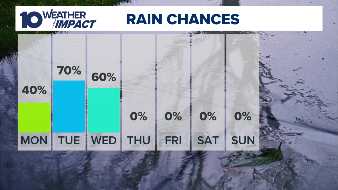
The severe weather will taper off before sunset, leaving another hot day Tuesday with more rain and a few storms possible.
Weather Resources:
Weather Impact Day
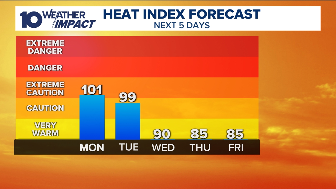
Elevated heat, humidity to push heat indices near 100 in central Ohio on Monday
Heat and humidity are persisting into Monday, leading to heat indices near 100 degrees.
A Weather Impact Day has been declared due to the increased temperatures. The time of highest concern will be during the afternoon and early evening when high levels of heat and humidity will make it hard to stay cool.
During this time period, you need to make sure you are taking plenty of breaks if you are working out in the heat. In addition, make sure you are staying hydrated and checking on those who may not have access to air conditioning.
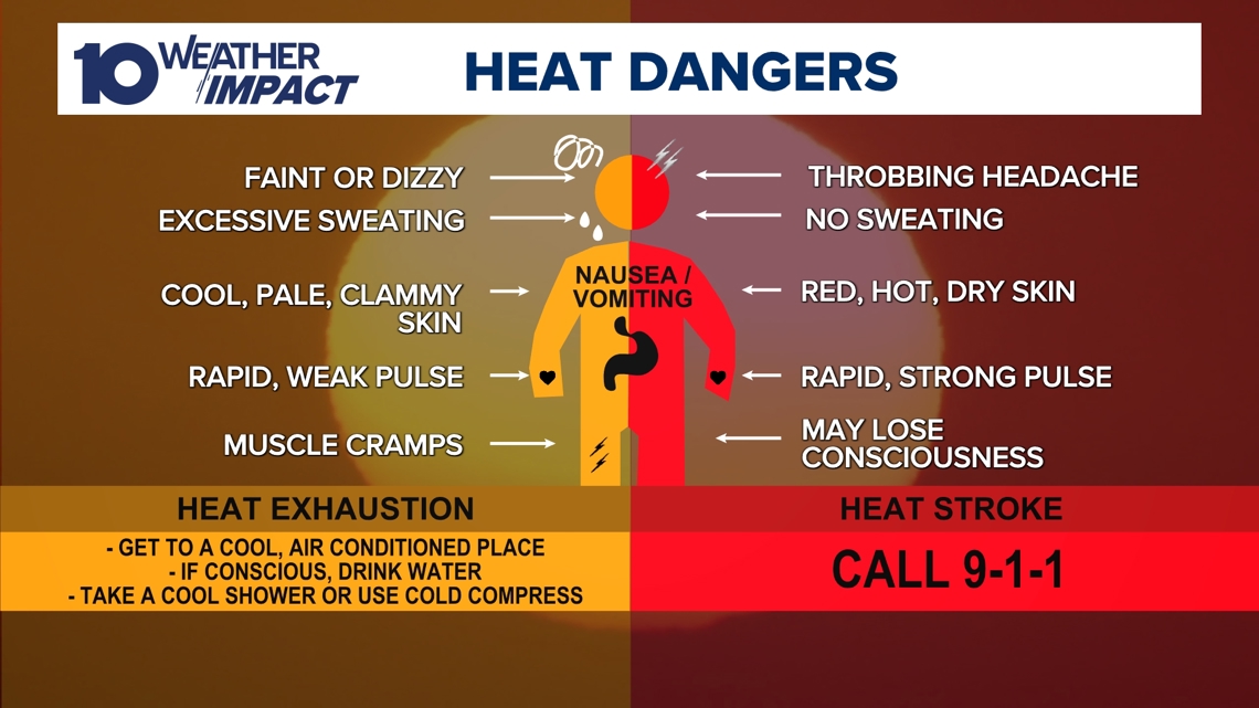
Make sure you are watching for signs of heat exhaustion or heat stroke both in yourself and those around you. A helpful guide to this is listed below.

While there is currently only one Weather Impact Day in place for now, it is possible that more could be added with our forecast this week. Dew points will remain high through the start of the work week, with heat index values back up near dangerous levels on Tuesday as well.

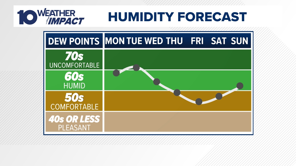
As of now, we are forecasting Tuesday to be slightly cooler, as the chances for showers and storms are better on Tuesday than on Monday. These will work to increase our cloud cover and keep afternoon highs and heat index values lower, despite what will likely be higher humidity levels.

Heat and humidity may lead to several rounds of showers and storms throughout Monday through Wednesday, with the best chances being on Tuesday and Wednesday. Some of these storms may be strong, so make sure you are staying weather aware!
The storms will however drop temperatures by the end of the week.

Stay cool, stay safe, and stay with 10TV for the latest updates!
-- Meteorologist Michael Behrens
Follow me on social media! Facebook Meteorologist Michael Behrens, X/Twitter @MikeBehrensWX, and Instagram/Threads @MikeBehrensWX.
Email me at: MBehrens@10tv.com
How to stay safe & cool in hot weather
Columbus Public Health reminds residents of ways to stay healthy and safe in hot weather:
- Drink plenty of water. Do not wait until you are thirsty.
- Stay in air conditioning whenever possible. If you do not have an air conditioner, use movie theaters, malls, libraries and other public places that are cool.
- Avoid beverages with alcohol, caffeine and sugar because they will dehydrate you.
- Eat light meals.
- Wear lightweight, light-colored clothing.
- Avoid strenuous activities and limit them to morning and evening hours.
- Learn the signs and symptoms of heat-related illnesses and how to treat them.
- Check on family members, friends and neighbors.
- Never leave people or pets in a closed car.