
As Tropical Storm Gonzalo churns in the central Atlantic Ocean, more than 1,000 miles off the coast of South America, a new threat is brewing much closer to the United States in the Gulf of Mexico.
"An area of low pressure associated with a tropical wave is currently moving through the central Gulf of Mexico," AccuWeather Senior Meteorologist Rob Miller said.
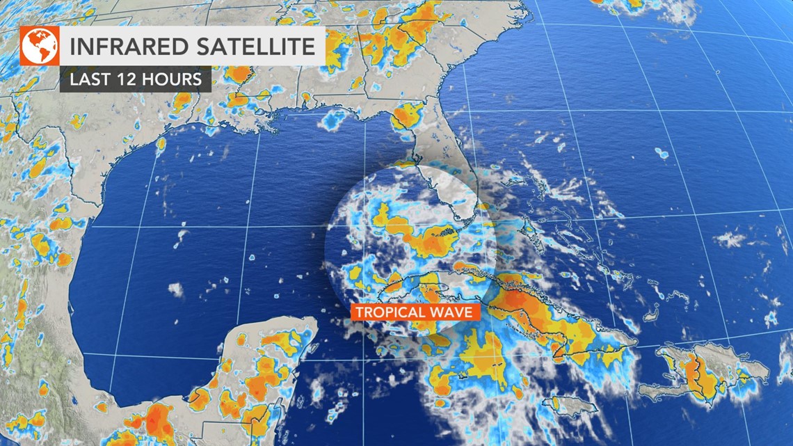
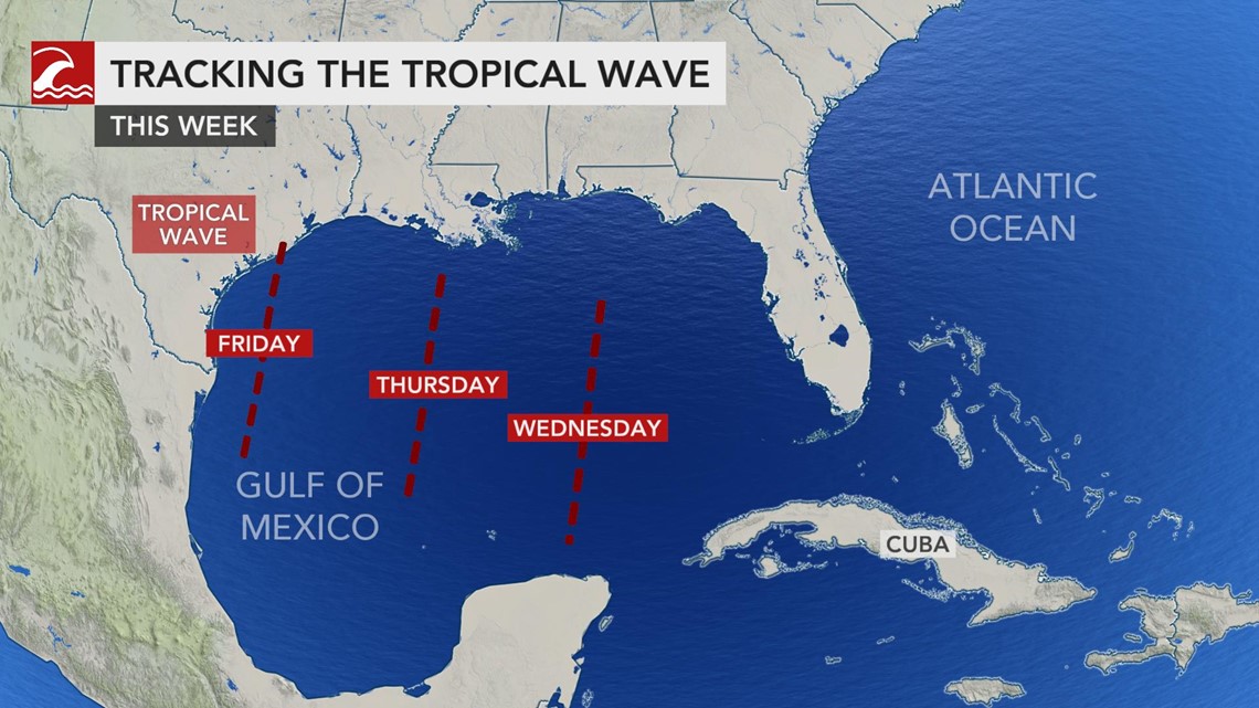
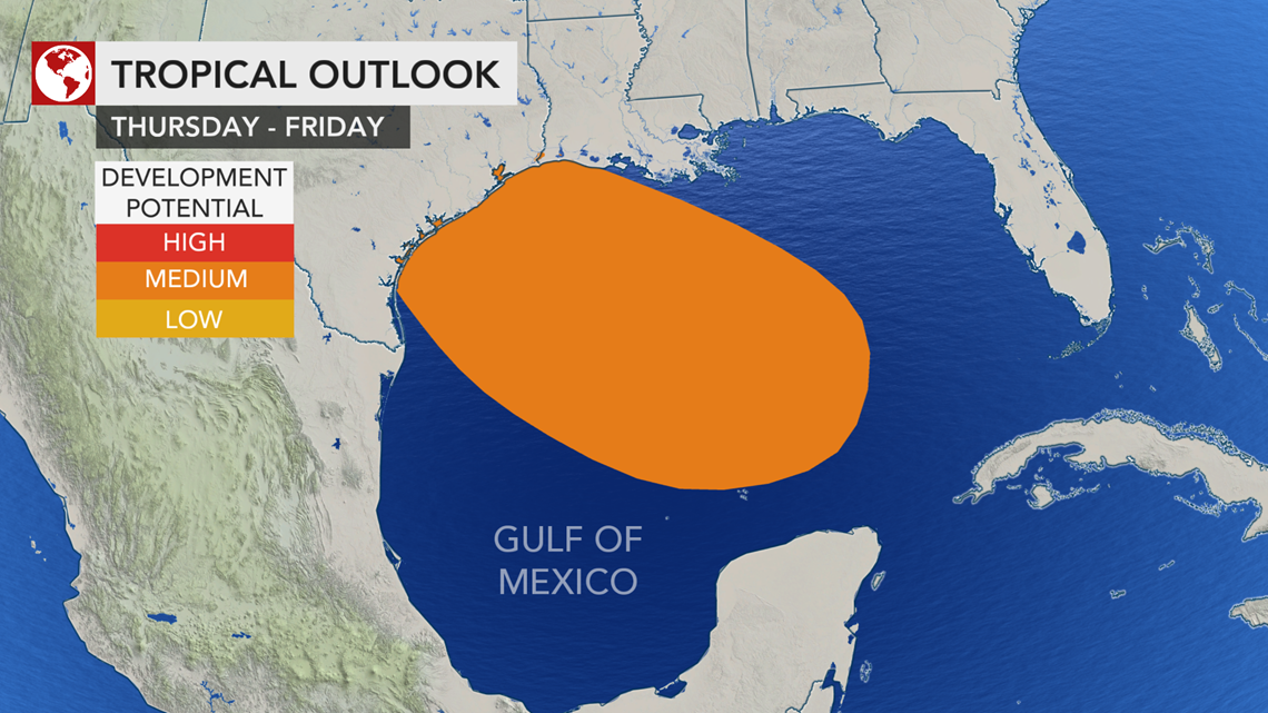
As of Wednesday morning, the tropical wave, dubbed Invest 91L by the National Hurricane Center (NHC), is producing disorganized showers and thunderstorms over the eastern Gulf of Mexico, reaching into central and southern Florida. It is expected to continue to trek in a west north-northwestern direction toward Texas.

"This low has the opportunity to strengthen into a tropical depression before moving over Texas Friday, as it will move through an environment featuring warm waters and light wind shear, though changing winds with altitude that can limit development," Miller said. "Regardless of this feature developing, locally heavy rainfall, enough to produce some flash flooding, will occur across parts of Louisiana and Texas Thursday into Saturday."

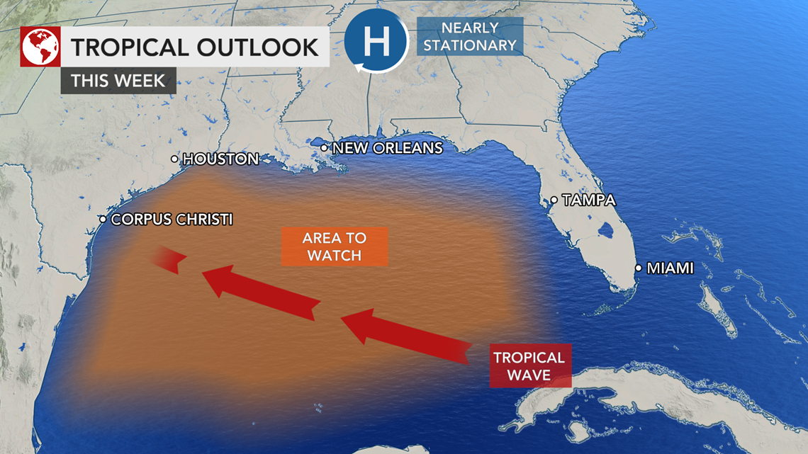
A general 2-4 inches of rain is forecast to fall mainly along the Texas and Louisiana coasts, including Houston and New Orleans and perhaps as far inland as Austin and San Antonio, Texas. An AccuWeather Local StormMax™ of 8 inches is anticipated.
Gusty onshore winds could also lead to rough surf and rip currents along the central and western Gulf Coast late this week into the weekend.
There is about a 40-50% chance of Invest 91L organizing into a tropical depression before reaching the Texan coast, according to Miller. The chances of it strengthening further into a tropical storm are even lower, at 10%.

The main limiting factor for development will be the short amount of time the system will take to trek across the Gulf of Mexico.
Should the system organize, it could become a depression by Thursday morning and could reach tropical storm strength by Thursday afternoon, Miller said.

"How much impact from wind will depend on the strength of the system as it move ashore in Texas," according to AccuWeather Senior Meteorologist Alex Sosnowski.
"Even in lieu of tropical storm formation, there can still be some gusty thunderstorms and perhaps a couple of tornadoes or waterspouts around the time of landfall at the close of the week," Sosnowski added.
If by chance, however slim it is, the storm reaches tropical storm status, it would be the earliest recorded "H" named storm in the Atlantic basin. The earliest eighth-named storm to date is Tropical Storm Harvey from 2005, which had formed on Aug. 3.
On Wednesday morning, the tropical depression that accompanied Invest 91L strengthened into Tropical Storm Gonzalo, becoming the earliest "G" named storm. Three tropical storms that proceeded Gonzalo -- Cristobal, Edouard and Fay -- had also been the earliest storms of their respective letters.
Invest 91L's current name comes from the NHC's naming conventions, "Invest" being short for "investigative area." The term is designated to areas of disturbed weather that meteorologists are monitoring for potential tropical cyclone development. However, the naming of an invest doesn't always mean that the area will turn into a tropical depression.
Each invest is assigned a letter and a number, adding to their description. The letter "L" in Invest 91L is assigned to all invests that are located within the northern area of the Atlantic Ocean, and there are different letters that correspond with both the basin they are in and the area of the basin. The letter that corresponds with the southern area of the Atlantic Ocean, for example, would be "Q."
As for the number, each invest is assigned a number from 90 to 99, which rotate throughout the season. The 91 in Invest 91L identifies it as the second invest identified in the northern Atlantic basin in the 2020 hurricane season.