Isaias ramped up to an 80-mph Category 1 hurricane during Thursday night, shortly after pulling away from Hispaniola and will now churn through the Bahamas, just north of Cuba, before making a run along the Eastern seaboard of the United States this weekend to early next week.
As a tropical storm, Isaias lashed Puerto Rico with 60-mph winds and heavy rains and made landfall in the Dominican Republic Thursday afternoon. The storm brought impacts to Haiti, the Dominican Republic's neighbor on the island of Hispaniola, also as it pushed northwest over the Caribbean.
Tropical Storm Isaias, pronounced ees-ah-ee-ahs, was upgraded from Potential Tropical Cyclone Nine status by the National Hurricane Center (NHC) at 11 p.m. EDT Wednesday. The system strengthened as it developed a more organized center with thunderstorms wrapping around its core -- and, with its upgrade, Isaias became the earliest "I-storm" in recorded history. The prior record holder was Irene from Aug. 7, 2005.
Isaias could become the second named system to make landfall in the U.S. in about a week following Hanna's arrival in South Texas on Saturday, July 25. But with the abrupt strengthening during Thursday night, a curved path could keep most of the hurricane-force winds east of the U.S. coastline.
"Florida may only get skimmed by the storm this weekend but the Carolina coast, which sticks out farther to the east is still vulnerable for a possible landfall early next week," AccuWeather Senior Meteorologist Alan Reppert said. "It will be losing wind intensity by that time though, but it still will bring rain, wind and rough surf, especially to the Florida and Carolina coastline."
During Thursday midday, Isaias was a tropical storm churning right along the southern coast of the Dominican Republic with maximum sustained winds of 60 mph and was racing west-northwestward at about 20 mph. Isaias's winds knocked out power to 300,000 people in Puerto Rico as of Thursday morning, where nearly 9 inches of rain led to incidents of flash flooding and landslides, according to The Associated Press.
When Isaias was upgraded to a hurricane late Thursday evening, it was about 80 miles southeast of Great Inagua Island, which is located north of the northwestern tip of the island of Hispaniola. It emerged over water after the center crossed the island, which consists of the countries of Haiti and the Dominican Republic.
By early Friday morning, Isaias was very near Great Inagua and was briskly moving northwestward at 17 mph.
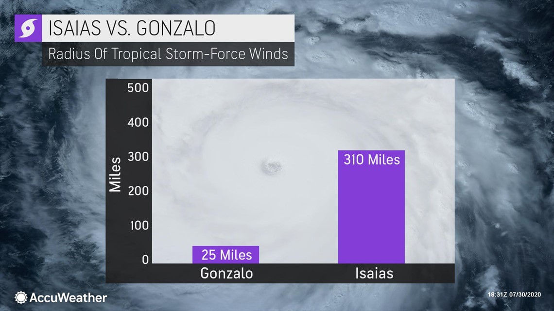
AccuWeather Senior Meteorologist Rob Miller cautioned that people should not focus on just the eye path given the sweeping size of Isaias. Tropical-storm-force winds extend outward by about 205 miles from the center on the storm's northeastern, northern and northwestern flanks. When compared to that of tiny Gonzalo from last week, the tropical-storm-force winds extend much farther out from the center.

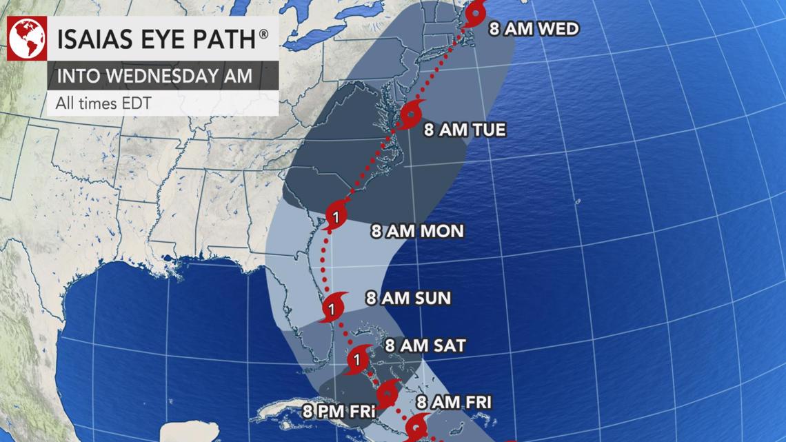
Torrential downpours, gusty thunderstorms and building seas are likely to precede Isaias by as much as 24 hours, which means that tropical storm conditions will spread northwestward across Cuba during through early Saturday and should begin in Miami during Friday night or early Saturday morning.

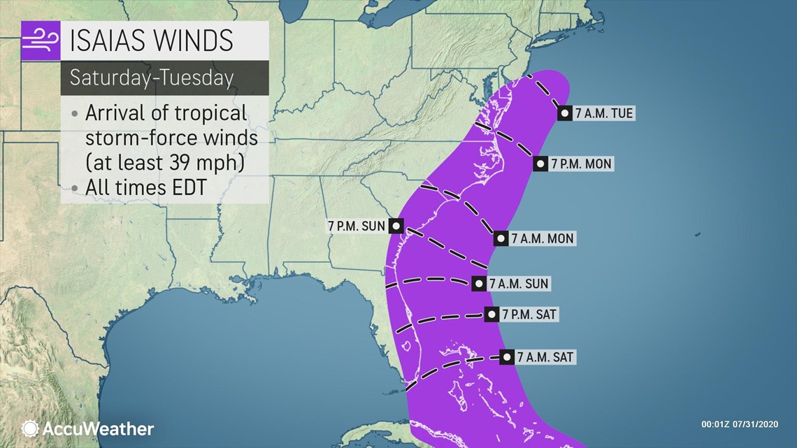
In the Bahamas, hurricane conditions are expected through early Saturday. Tropical storm conditions could then spread across Florida over the weekend. Adding onto this, the system is racing along at approximately twice the average speed of tropical systems for this area of the basin.
All interests from the Dominican Republic and Haiti to Cuba, the Bahamas, Bermuda, the eastern U.S. and Atlantic Canada are urged to monitor the progress of Isaias.

Hurricane warnings were in effect for the Bahamas, as well as the Turks and Caicos, while portions of the Dominican Republic and Haiti were under tropical storm warnings early Friday morning.
Isaias is forecast to be a 1 for the Bahamas on the AccuWeather RealImpact™ Scale for Hurricanes, a more nuanced method the company introduced in 2019 to assess the potential damage a tropical system could cause, across the northern Caribbean into Friday and the southeastern U.S. this weekend. As Isaias curves north and approaches the Carolina coast, it is also forecast to be a 1 on the AccuWeather RealImpact™ Scale in the United States.
Isaias is expected to remain a Category 1 hurricane later on Friday as it moves into the Bahamas, hitting the warmer waters after trudging its way through the Hispaniola mountains, which are a major hurdle for tropical systems. However, the center of the storm remained well defined Thursday night as it moved off the northern coast of Hispaniola, having missed the highest terrain of the island that could have unraveled it.

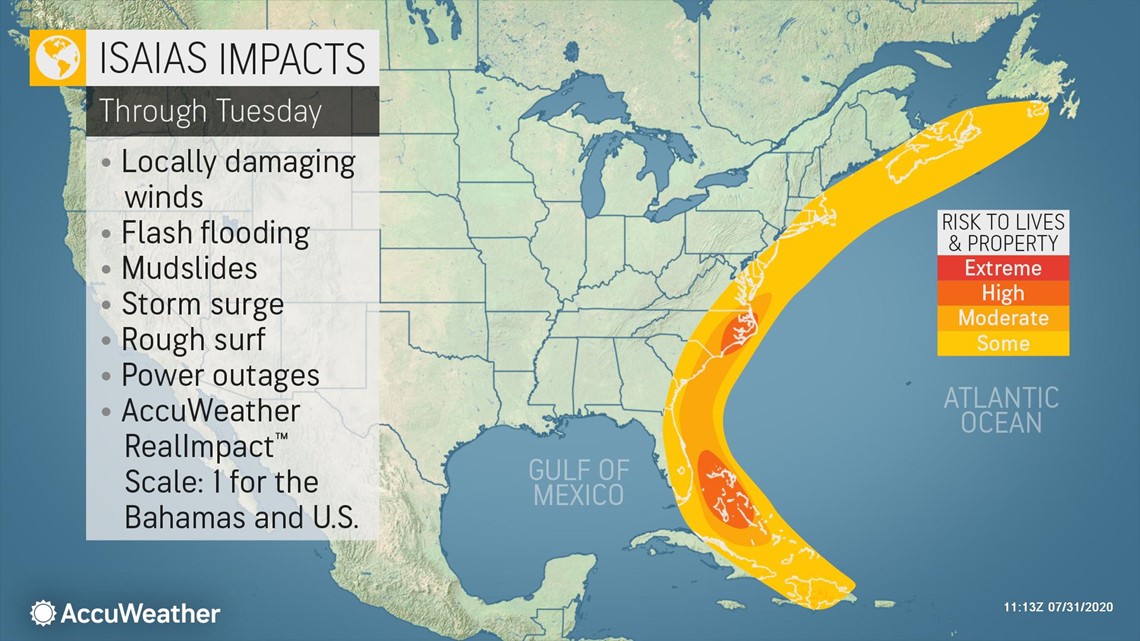
As Isaias approaches North America, a non-tropical system associated with a dip in the jet stream located over the U.S. will likely influence its movement and strength.
"We sometimes see jet stream troughs like this draw tropical systems closer in to the U.S., rather than drive them away," AccuWeather Chief Broadcast Meteorologist Bernie Rayno said.
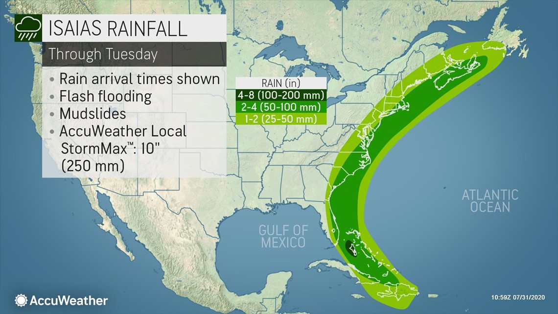
The fast-forward motion of Isaias should limit the overall amount of rain, but there can still be incidents of urban flooding in the Bahamas, parts of Cuba and from Florida to the Carolinas. In these areas, from 2-4 inches of rain may fall with locally higher amounts, but precipitation amounts will be influenced by the storm's path. A track farther to the east would bring less rain to the U.S. and Cuba and more rain to the Bahamas, for example.

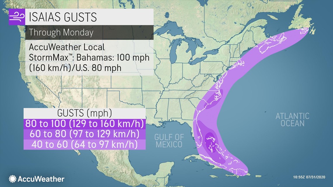
Wind gusts of 60-70 mph can occur across eastern Florida, with higher gusts of 80-90 mph expected across the northwestern Bahamas. An AccuWeather Local StormMax™ wind gust of 100 mph is possible over the northwest Bahamas.

Florida is one of the states that has been experiencing a tremendous surge in coronavirus cases over the last month. On Wednesday, the state reported 253 COVID-19 fatalities, the third daily death record in a row, according to the Orlando Sentinel. The state has had over 6,300 deaths since the pandemic began, data from the John Hopkins University shows.
With the potential for a strike from Isaias looming, health officials in Collier County, which encompasses Naples on the state's Gulf Coast, announced Tuesday that two testing clinics would be shut down ahead of Isaias. A walk-up testing site in Immokalee will close down on Thursday, and one in Naples will be shuttered on Friday, officials said on Twitter. Thursday evening it was announced that state-supported COVID-19 testing sites in a handful of counties including Escambia, Polk, Sarasota and Leon would remain open. Meanwhile, Florida Gov. Ron DeSantis on Wednesday urged Floridians to "prepare now by having at least 7 days of disaster supplies" on hand.
The name Isaias was added to the Atlantic list after Ike caused destruction in Texas in 2008 and was retired in 2009. It has not yet been used.
Could 2020 break more tropical storm records?
AccuWeather's top hurricane expert Dan Kottlowski issued an update to the numbers of tropical storms and direct impacts to the United States for the Atlantic season this week. He warned that the tropics could become "hyperactive" as the heart of hurricane season nears, and that one area in particular should remain "very vigilant" of the pattern setting up.

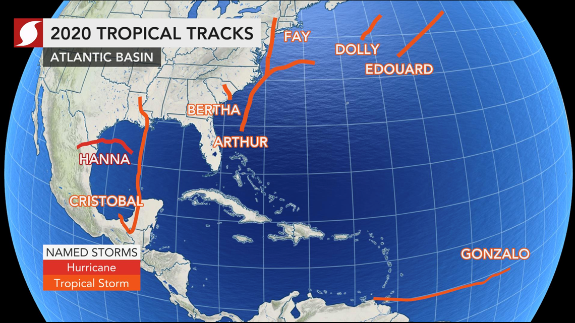
Six of the nine tropical storms thus far in 2020 have set new records for early formation for their respective letters in the basin -- Cristobal, Edouard, Fay, Gonzalo, Hanna and Isaias -- and more are likely to fall as the season progresses, according to forecasters. The "J-storm" record is currently held by Jose on Aug. 22, 2005, with the "K-storm" record held by the infamous Katrina, which formed on Aug. 24, 2005.
The 10th and 11th names on this year's tropical list are Josephine and Kyle. For more names on the 2020 Atlantic list and all tropical weather information, please visit the AccuWeather hurricane center.

