For the past five years, a satellite orbiting nearly one million miles from home has been capturing images of the Earth, but early in its mission, it revealed a side of the planet's cosmic partner that goes unseen even to the largest telescopes.
On Feb. 11, 2015, NASA and NOAA launched the Deep Space Climate Observatory (DSCOVR), a satellite that sits around 1 million miles away from the Earth. At this precise spot, the satellite is in what is called a "neutral gravity point" between the Earth and sun, allowing it to continuously monitor the two objects at the same time with little interference.
The Earth-facing camera on DSCOVR "maintains a constant view of the fully illuminated Earth as it rotates, providing daily scientific observations of ozone, vegetation, cloud height, and airborne aerosols," NASA said.
The satellite may be 1 million miles from home, but the high-resolution camera outfitted on DSCOVR reveals details on the planet's surface and weather phenomenon in the atmosphere.
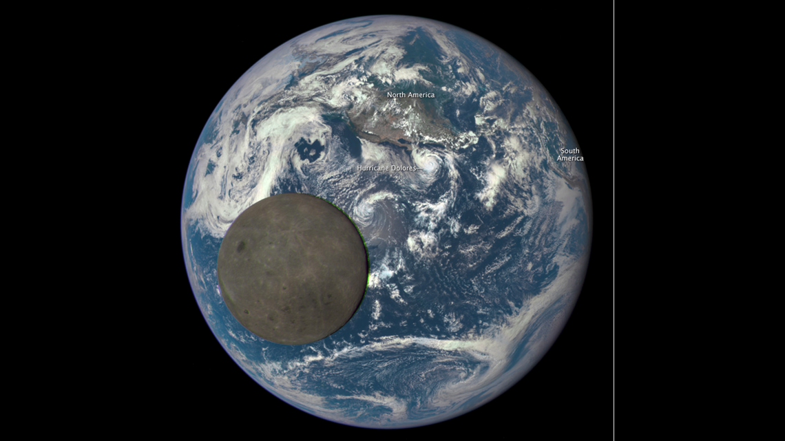
On July 16, 2015, DSCOVR spotted Hurricane Dolores churning over the eastern Pacific Ocean shortly before it ushered flooding rainfall into Southern California. In the very same photo the satellite captured of Dolores, an otherworldly object blocked part of its view of the Earth, nearly eclipsing the hurricane below.


On that day five years ago, DSCOVR shed some light on the "dark side" of the moon as it passed directly between the satellite and the Earth.
This occasion was significant because it allowed scientists to see the half of the moon that is always facing away from the Earth. Only satellites farther away than the moon, which is approximately 238,000 miles from the Earth, can accomplish this feat.
From its vantage point 1 million miles away from home, scientists can use DSCOVR to study features on the far side of the moon, an opportunity that doesn't present itself on a regular basis.
"About twice a year the camera will capture images of the Moon and Earth together as the orbit of DSCOVR crosses the orbital plane of the Moon," NASA said.
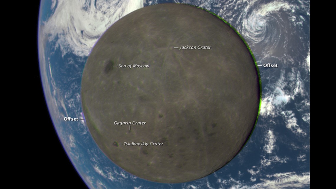
The images relayed back to Earth have enough detail to pick out features of the moon's surface that are never visible from Earth. This includes the 44-mile-wide Jackson Crater and the "Sea of Moscow," which is one of the very few areas on the far side of the moon that was formed by an ancient volcanic eruption.


Almost as rare as photographing the far side of the moon is capturing images of the moon's shadow during a solar eclipse.
Throughout its mission, which is still ongoing, DSCOVR has spotted solar eclipses all around the globe, including the Great American Eclipse, which darkened the sky over North America on Aug. 21, 2017.
Not only did the satellite capture the shadow of the moon traversing North America on that summer day, but the photo also included a cluster of clouds in the western Caribbean Sea that would eventually strengthen into Hurricane Harvey, which slammed into the Gulf Coast as a Category 4 storm eight days later.
As breathtaking as some of these images can be, it is only part of DSCOVR's mission.
The satellite's primary mission is to monitor space weather and transmit real-time data to scientists at NOAA about the solar wind being emitted from the sun. This solar wind can cause the aurora to dance across the night sky, but it can also be harmful to satellites, and in some cases, harmful to the power grid on Earth.
On March 13, 1989, the entire power grid across Quebec went down due to a significant solar storm. Millions of people found them self in the dark for more than 12 hours, according to NASA.
"DSCOVR will typically be able to provide 15 to 60 minute warning time before the surge of particles and magnetic field, known as a coronal mass ejection (or CME), associated with a geomagnetic storm reaches Earth," NOAA said.
"DSCOVR data will also be used to improve predictions of geomagnetic storm impact locations. Our national security and economic well-being, which depend on advanced technologies, are at risk without these advanced warnings."
Images from DSCOVR are openly available on NASA's website where people can step back in time to see what the planet looked like from 1 million miles away all the way back to mid-2015.


